Coastal Flood Advisory Update: 3 New Jersey Counties Warned as High Tides Threaten Through Thursday Evening
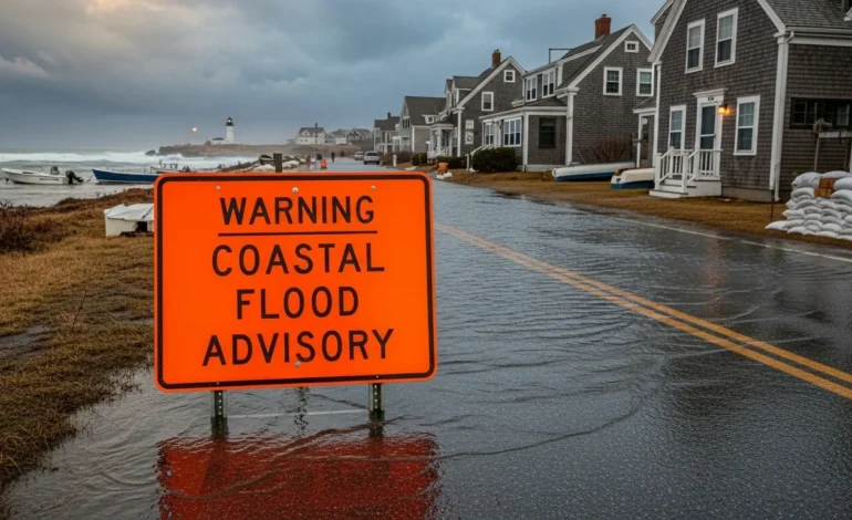
Table of Contents
A coastal flood advisory is currently in effect for parts of New Jersey, as high tides and strong onshore winds combine to threaten low-lying coastal areas. According to the National Weather Service (NWS) office in Mount Holly, the advisory spans the counties of Atlantic County, Cape May County, and Ocean County, with impacts expected through 8 p.m. EDT Thursday, October 30, 2025.
Minor tidal flooding—up to one foot above ground level in some low-lying spots—is possible, especially near bayfront and tidal waterways.
This update reviews the scenario, what to expect, and how residents and visitors can respond.
What the Advisory Covers
Affected Areas and Timing
The NWS advisory encompasses Atlantic County’s ocean-front and back-bay zones, Cape May County’s coastal shoreline, and Ocean County’s bay and ocean interface.
The timing is specific: the advisory remains valid until 8 p.m. EDT Thursday.
High tide cycles drive the timing of greatest risk: for example, in the Ocean County region, the bay-side high tide occurs at about 6:27 p.m. in Barnegat Bay and 7:15 p.m. at Mantoloking Bridge.
This means the peak potential for coastal flooding aligns with late afternoon to early evening high tide periods.
Nature & Magnitude of Impact
The advisory warns of “up to one foot of inundation above ground level” in vulnerable low-lying coastal and tidal areas.
In terms of tide gauges, for example: in the Great Egg Harbor Bay at Ocean City, predicted peaks are about 5.7 ft MLLW (Mean Lower Low Water) on Oct 30, which is considered in the “minor flooding” category.
Additionally, onshore winds are expected with gusts up to 50 mph, and rainfall of 1-2 inches, locally reaching 3 inches, further complicating drainage in low zones.
This data shows that while major structural flooding isn’t likely, roadway closures, standing water, and coastal roadway inundation are credible risks.
Key Weather Drivers
Onshore Wind & Surf Conditions
A strong storm system is pushing northeast across the region, generating persistent onshore winds and elevated surf. The NWS briefing for the Philadelphia/Mount Holly office notes seas of 10 to 15 feet in near-shore ocean waters.
East winds at 25-35 mph with gusts up to 50 mph are expected particularly in the Ocean County zone.
The combination of high surf and onshore push means water is being forced into bay areas and low-lying coastal roads rather than draining quickly.
Rainfall & Drainage Issues
Forecasts call for 1 to 2 inches of rain across the region Thursday, with isolated amounts up to 3 inches.
In coastal zones already experiencing tidal build-up, even moderate rainfall can cause minor flooding of urbanized or poor-drainage areas.
This shows that the risk is twofold: tidal flooding from the sea and surface runoff from rainfall compounding in low spots. For residents and local authorities, this means pre-emptive clearing of storm drains matters.
Impacts for Residents, Visitors & Infrastructure
The advisory means residents, visitors, and businesses in the three counties should act with caution. Roadways closest to the shoreline and bayfront are most vulnerable to flooding. In Ocean County, partial or full road closures are possible late Thursday afternoon.
Parking in low-lying lots should be avoided during the evening high tide. The advisory emphasises: do not drive through water-covered streets.
Beach erosion risk is elevated: older dune structures and properties already recovering from recent storms may see additional loss of sand and shoreline.
For visitors, planning travel before the high tide window or avoiding coastal roads during peak tide is prudent. Local emergency management is likely monitoring conditions and may issue further statements if the situation worsens.
Investor Reaction / Market Sentiment
Though this advisory is primarily a weather-event update, it indirectly touches on real-estate, insurance, and municipal infrastructure sectors. For instance, properties within the affected counties may face higher operating costs, such as increased insurance premiums or storm-damage mitigation budgets.
Municipalities in the region may allocate additional funds for storm water infrastructure, beach restoration and emergency services, which could impact local budgets and investment in public works.
From a sentiment viewpoint, stakeholders (residents, businesses) are likely to adopt risk-aversion behaviours in the next 24-48 hours—cautious access, reduced activity near shores, and greater attention to expeditious storm-preparation. This shows that even minor flood advisories can ripple into operational and financial readiness decisions.
Bottom Line
In summary, the coastal flood advisory for Atlantic, Cape May and Ocean counties in New Jersey reflects a minor but real risk — up to one foot of inundation in vulnerable areas through 8 p.m. Thursday, Oct 30 2025. Strong onshore winds, elevated surf, and modest rainfall combine to raise the threat for tidal-driven roadway flooding, beach erosion and drainage challenges. For residents, visitors and infrastructure operators, awareness and early action matter: avoid low-lying coastal roads, park at higher elevations, secure outdoor items, and monitor updates from local authorities. Looking ahead, once high tide subsides and winds drop, the situation should diminish, but recovery and assessment may continue. Adjusting behaviour now will reduce risk and protect homes, propert,y and community services.
FAQs
What exactly does the coastal flood advisory mean?
A coastal flood advisory signifies that minor tidal flooding is expected in low-lying coastal zones. It does not mean major flooding or evacuation is imminent, but streets may be inundated, and travel could be affected. The NWS defines this level of flooding as likely to impact “the most vulnerable roadways.
Which areas are most at risk in this event?
Areas at highest risk are low-elevation beachfront roads, bayfront lots, and tidal back-bay communities in Atlantic, Cape May and Ocean counties. According to the advisory, built-up areas near tidal waterways are especially vulnerable.
How long will the flooding risk last?
The advisory is in effect until 8 p.m. EDT Thursday, October 30, 2025. The greatest risk coincides with late afternoon to early evening high tides and persistent onshore winds. After that time the risk is expected to diminish.
Should I evacuate or worry about my property?
For most properties, this advisory calls for caution—not evacuation. Homeowners should move vehicles away from vulnerable zones, secure outdoor objects, and stay off inundated roads. If you are in a specially flood-prone building or have been advised by local authorities to relocate, follow those instructions promptly.